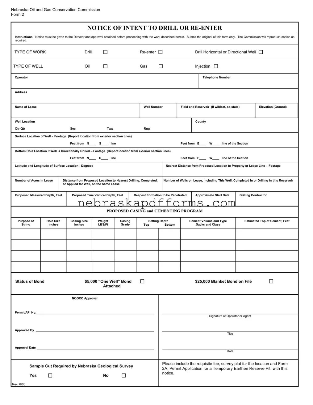
Nebraska 2 Form
The Nebraska 2 form is an essential document for those involved in the oil and gas industry in Nebraska. It serves as a Notice of Intent to Drill or Re-enter, requiring operators to notify the Nebraska Oil and Gas Conservation Commission before commencing any drilling activities. This form must be completed and submitted in its original format, as the Commission will handle the reproduction of any necessary copies. Operators must specify the type of work they plan to undertake, whether it’s drilling a new well, re-entering an existing one, or drilling a horizontal or directional well. Key details include the type of well—be it oil, gas, or injection—and critical information such as the well's location, elevation, and proximity to property lines. The form also requires operators to outline their proposed casing and cementing program, including specifics like hole size, casing size, and the estimated volume of cement. Additionally, the operator must provide information about the drilling contractor, the proposed depths, and any necessary bonds. Completing the Nebraska 2 form accurately is crucial for ensuring compliance with state regulations and facilitating a smooth drilling process.
Document Preview Example
Nebraska Oil and Gas Conservation Commission
Form 2
NOTICE OF INTENT TO DRILL OR
Instructions: Notice must be given to the Director and approval obtained before proceeding with the work described herein. Submit the original of this form only. The Commission will reproduce copies as required.
TYPE OF WORK |
Drill |
Drill Horizontal or Directional Well
TYPE OF WELL |
Oil |
Gas
Injection
Operator
Telephone Number
Address
Name of Lease
Well Number
Field and Reservoir (If wildcat, so state)
Elevation (Ground)
Well Location |
|
|
|
|
County |
|
|
|
Sec |
Twp |
Rng |
|
|
|
|
|
|
|
|
|
|
|
|
|
|
|
Surface Location of Well - Footage |
(Report location from exterior section lines) |
|
|
|
|
|
|
|
|
Feet from N____ |
S____ line |
Feet from |
E____ |
W____ |
line of the Section |
||
|
|
|
|
|
|
|||
Bottom Hole Location if Well is Directionally Drilled – Footage (Report location from exterior section lines) |
|
|
|
|
||||
|
Feet from N____ |
S____ line |
Feet from |
E____ |
W____ |
line of the Section |
||
|
|
|
||||||
Latitude and Longitude of Surface Location - DEGREES |
|
Nearest Distance from Proposed Location to Property or Lease Line - Footage |
||||||
|
|
|
|
|
|
|
|
|
Number of Acres in Lease
Distance from Proposed Location to Nearest Drilling, Completed, or Applied for Well, on the Same Lease
Number of Wells on Lease, Including This Well, Completed in or Drilling in this Reservoir
Proposed Measured Depth, Feet
Proposed True Vertical Depth, Feet
Deepest Formation to be Penetrated
Approximate Start Date
Drilling Contractor
PROPOSED CASING AND CEMENTING PROGRAM
Purpose of
String
Hole Size
Inches
Casing Size
Inches
Weight LBS/Ft
Casing
Grade
Setting Depth
Top Bottom
Cement Volume and Type
Sacks and Class
Estimated Top of Cement, Feet
Status of Bond |
$5,000 “One Well” Bond |
|
Attached |
$25,000 Blanket Bond on File
|
|
|
NOGCC Approval |
|
|
|
|
Permit/API No. |
|
|
|
|
|
||
|
|
|
|
|
|
Signature of Operator or Agent |
|
Approved By |
|
|
|
|
|
||
|
|
|
|
|
|
Title |
|
Approval Date |
|
|
|
|
|
||
|
|
|
|
|
|
Date |
|
|
|
|
|
|
|
|
|
Sample Cut Required by Nebraska Geological Survey |
|
|
Please include the requisite fee, survey plat for the location and Form |
|
|||
|
|
2A, Permit Application for a Temporary Earthen Reserve Pit, with this |
|
||||
|
|
|
|
|
|
|
|
Yes |
No |
|
|
notice. |
|
||
|
|
|
|
||||
Rev. 6/03
File Information
| Fact Name | Details |
|---|---|
| Governing Law | The Nebraska Oil and Gas Conservation Commission regulates the Form 2 under Nebraska Revised Statutes, Chapter 57. |
| Purpose of the Form | This form serves as a Notice of Intent to Drill or Re-enter a well, ensuring that the operator receives necessary approvals before commencing work. |
| Types of Work | Operators can indicate whether they intend to drill, re-enter, or drill a horizontal or directional well. |
| Information Required | Key details include operator information, well location, elevation, and the type of well being drilled. |
| Location Details | The form requires specific location data, such as the feet from section lines and latitude and longitude coordinates. |
| Proposed Depths | Operators must provide both the proposed measured depth and the proposed true vertical depth of the well. |
| Casing and Cementing Program | The form requires a proposed casing and cementing program, detailing the purpose, hole size, casing size, and cement volume. |
| Bond Requirements | Operators must indicate the status of the bond, which can be a $5,000 “One Well” bond or a $25,000 blanket bond. |
| Approval Process | Submission of the original form is necessary for approval, and the Nebraska Oil and Gas Conservation Commission will reproduce copies as needed. |
Other PDF Templates
Does Nebraska Have a State Income Tax - This tax agreement form is for nonresidents who earn income in Nebraska to file and pay state taxes.
Understanding the Colorado Do Not Resuscitate Order is crucial for anyone considering end-of-life options. This important document ensures your medical wishes are clear, offering a way to express a preference against receiving CPR. For more information about this form, visit our guide on the understanding of the Do Not Resuscitate Order process.
Are Blue Lights on Cars Illegal - Crucial for any entity seeking to improve road safety through the strategic placement of red light cameras.